Link do wersji polskiej: https://sp3vss.eu/active-aprs-tracker/
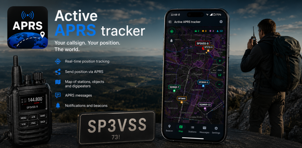
The Active APRS Tracker application is used for APRS operation and transmitting frames using an Android phone.
This application is an Android app for amateur radio operators. It allows reporting your position to the APRS (Automatic Packet Reporting System) network, displaying nearby amateur radio stations, and exchanging APRS messages.
Latest version at the end of the page!
Basic features:
Using APRSdroid, you can connect to the APRS network in various ways:
APRS-IS via the Internet (WiFi or mobile data connection)
Coming soon:
- Bluetooth serial connection to a TNC
- Audio connection between the radio and the smartphone)
- KISS IP
- Reading from the Kenwood TRX
- User Profiles
- Digipeater & I-Gate
1. Main screen and status information
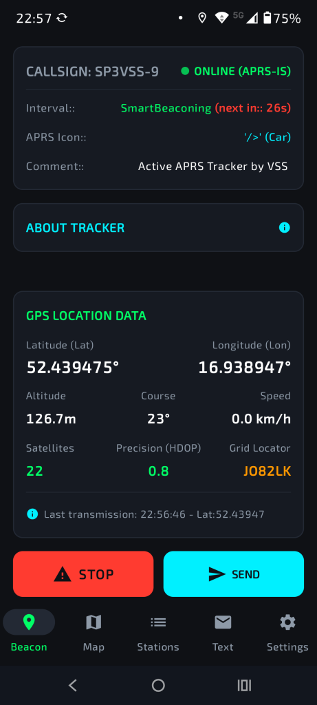
After launching the application, the main screen provides key information about the current status of the program:
- Connection status: Information on whether the server is connected and the user’s amateur radio callsign.
- Transmission parameters: The frame sending interval, selected icon, and comment are displayed.
- GPS data: Latitude and longitude, altitude, speed, number of received satellites, and reception accuracy (the lower the value, the better).
- Locator and Satellite Window: Clicking the GPS data opens a window with an azimuth sky map, which rotates according to the compass, making it easier to locate satellites. It also contains signal strength (SNR), UTC/local time, and sunrise and sunset data.
2. Configuration and Settings
To go to settings, select the appropriate option from the menu. The key parameters are:
- Identification data: Callsign, SSID, and server password.
- Station icon: You can choose an icon from the list or enter it manually. Selecting some icons (e.g. car, bicycle) automatically changes the SSID to -9, and runner to -7.
- Operating mode: You can enable the „No frame transmission” option, which turns the application into a local situation monitor (receive only).
- Frame parameters: Ability to enable/disable sending speed, course, and altitude in the APRS frame3
- Server: APRS server address and port, and the position sending interval (in seconds)3.
- Filtering: Range of stations downloaded from the server
- New in version 1.2: Added the screen sleep lock option (the screen will always stay on) and connection type selection (currently Internet is active)
3. Beacon operation
In the „Beacon” tab, the user manages transmission of their own position:
- Start/Stop: A button that starts the connection to the server. Once the connection is established, the status „Online” is displayed.
- Countdown: The application shows in how many seconds the next frame will be sent.
- Manual sending: The „Send” button allows immediate transmission of a frame. In version 1.2, this button also works without pressing „Start”, which allows a single position transmission without full login to the system.
4. Station list and sorting
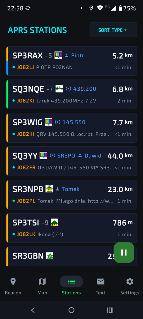
The list of received stations contains information about other users within range:
- Color markings: Weather stations (purple bar), mobile stations (green), fixed/home stations (orange-yellow).
- Favorites: Stations marked as favorites have a blue bar and are always displayed at the very top of the list.
- Sorting (v1.2): Ability to sort stations by frame reception time, distance, type (mobile, fixed, weather), and callsign (alphabetically).
- Pause: The pause button stops refreshing the list, allowing you to calmly review the data of a specific station
5. Station details and navigation
Clicking a station on the list opens a details window:
- Technical data: Distance, course, azimuth, geographic position, locator, telemetry (for weather stations), and raw frame
- The Favorites button marks the station
- The Message button takes you to the message sending window and automatically fills in the callsign.
- Direction finding: This function shows the user’s azimuth and the direction to the station using an arrow, allowing real-time direction finding
- Navigation (v1.2): The „Navigate to Google Maps” button automatically starts external navigation to the position of the selected station10.
- Station geographic data
- Telemetry (if present)
- Raw frame
6. Notifications (New in version 1.2)
The user can set notifications for the arrival of a new frame from a specific station:
- Notification types: Ringtone (selected from the system), LED flash (200 ms), vibration (500 ms), and popup window. Below is the alarm ringtone selection button (it can be different for each callsign).
- Indication: Stations with notifications enabled are highlighted in the list with a red description color
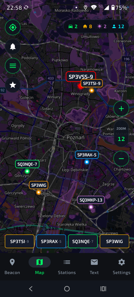
7. Map
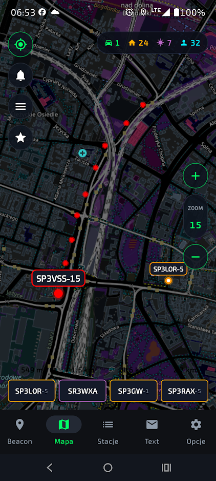
The map visualizes the position of all received stations:
- Symbols: Your own station is larger and red. Other stations have colors according to their type (green, orange, purple), and favorites have a blue outline
- Map functions:
- Crosshair: Centering the map on your own position.
- Bell (v1.2): Quick enabling/disabling of notifications directly from the map
- Map: map color selection: light/dark/system
- Star: Hiding all stations except favorites
8. Communication and additional tools
- Messages: The application allows sending text messages to other stations and viewing the log of all messages
- Event log: View of sent and received frames in real time, with options to clear and refresh13.
- Compass calibration: A tool that helps calibrate the phone’s sensors by performing figure-eight movements. This is necessary for proper operation of station direction finding and the satellite map
Version: 1.1 – 01.06.2026
- added detailed GPS information
- added detailed station information with navigation capability
- added compass calibration
- added favorites and a way of marking them on the list
- changed the icons on the bottom bar
- added sending speed, course, and altitude in the frame
- added the possibility to choose the icon manually
- added automatic SSID selection based on the station
- defined the behavior of the buttons on the left side of the map
- added display of the number of stations on the map in the upper right corner
Download the application:
Below is a video discussing the basic functionalities:
Version: 1.2 – 02.02.2026
- added sorting in the list: callsign, time, distance, type
- added station notifications: LED, vibration, window, ringtone.
- changed the way stations with enabled notifications are displayed
- added a connection type option (currently only Internet works).
- added screen timeout lock
- added information about the author
- improved the color scheme of the bottom bar
- organized the options in settings
- added a button for automatic navigation to the station in Google Maps
- improved the operation of the SEND button – it works regardless of the START button state
Download the application:
Version: 1.2.1 – 02.02.2026
- fixed it so that the SEND and START buttons are visible on phones with lower resolution.
Version 1.2.2 – 07.06.2026
- fixed it so that when favorites are enabled on the map, only favorites appear on the bottom bar
- changed the default comment
- screen rotation does not cause exiting windows
- fixed it so that after selecting sorting, going to the map, and returning, the sorting system remains
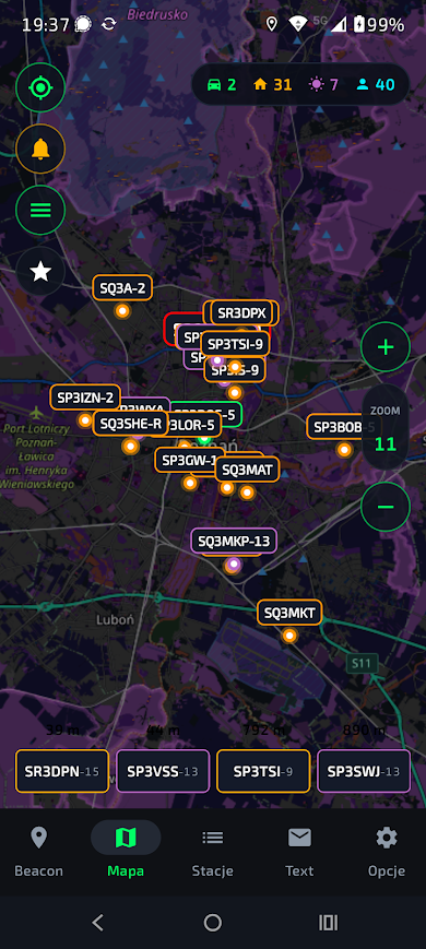
- added font scaling on the map
- added a marker for your own station on the map
- added map selection – light/dark/system
Version 1.2.3 – 08.06.2026
- grouped settings in the „Options” tab
- added SmartBeaconing™
- added English language
- added course information to GPS data
- for fixed interval, added the option to send frames every specified distance
- trail of the last 10 frame transmission points of your own station